TECHNICAL

A suite of technical surveys and assessment work has been carried out to inform the proposed scheme.

A summary of the key technical work is set out below.

Transport and Connectivity


ACCESS

A newly formed site access is proposed to provide a legible route to and from the site. This access will be designed to facilitate simple, non-conflicting movement between different users and modes. The design of the site access will be prepared in accordance with all relevant national and local design guidance, as well as being subject to a Road Safety Audit. The proposals will extend the existing 30mph zone past the site frontage on Mallory Road. It is currently proposed that this route is formally offered for adoption to allow council run services to access the site.

A dedicated pedestrian route is proposed in the northeastern corner of the site to facilitate access to the existing bus stops located on Mallory Road. This increases the site permeability and access to non-car modes of transport. This route will also facilitate access to the heart of the village, connecting directly 

with the existing network of footways and crossing facilities to the east.

More centrally, the site will maintain the existing Public Right of way alignment which offers an alternative route for pedestrians to travel east/west through the site and further afield as part of either day-to-day or leisure trips.

The public realm will be designed with inclusivity as a central theme, providing routes for all age groups and abilities, including disabled, blind and partially sighted users.

Further afield, consideration will be given to any potential impacts resulting from the proposals, including off-site highway modelling and mitigation reviews. A thorough review of the existing safety records on the local highway network will be completed to ensure any residual impacts can be resolved.

PARKING AND LOADING

Parking and loading will be carefully considered as part of the ongoing design development. Key to the successful delivery of this site however is ensuring adequate space is made for both resident and visitor parking, giving the location of the site in the wider transport network context. This will be informed, in the first instance, by local design standards but will also be thoroughly reviewed throughout the preparation and consultation stages to ensure the correct provision is made. This will include provisions for blue badge parking.

Electric vehicle charging points will be provided for each individual dwelling with an allocated vehicle space to facilitate the adoption of low emission vehicles across the site.

Landscape


THE SITE AND CONTEXT

The site comprises several broadly rectangular fields in an edge of settlement location, adjacent to Bishop’s Tachbrook. The site’s key landscape features are restricted primarily to the site’s boundaries and internal subdivision where c.1.8m tall tightly flailed, gappy hedgerows bound the closely grazed fields, the northern and western boundaries are formed by belts of tree planting. Within the northeastern field is a seasonally wet pond which is partially encircled by semi-mature trees. Groups of mature hedgerow trees also feature within the northern and northwestern boundary, with a larger group lying immediately adjacent to the northeastern boundary. In broad terms, the site occupies the north-facing aspect of a localised ridgeline, sharing this aspect of the ridgeline with much of the existing settlement at Bishop’s Tachbrook.

Within the site itself, an existing public right of way (footpath no. W106) extends across the site, providing a link to the wider countryside via Hareway Lane. Mallory Road forms the northern boundary of the site. Several properties are accessed from this road, to the north-west and north of the site and where it forms the northern boundary of the site. Mallory Road is further urbanised by its signage and street lighting on the approach into Bishop’s Tachbrook.

In broad terms, the primary visibility of the site would likely be contained within the immediate influence of Bishop’s Tachbrook. Beyond this, the pattern of visibility of the site begins to fragment, principally because of the undulating topographical context and blocks of woodland and individual mature trees.

THE PROPOSALS

A landscape response is illustrated on the Illustrative Masterplan which has been informed by baseline studies and identifies that any proposals should seek to retain existing noteworthy landscape fabric and features, to be complemented by additional hedgerow and tree planting. The current footpath is shown on its existing alignment, with a generous swath of POS space extending for the sites high point at the south east, where there is an opportunity to provide connectivity into the recently constructed open space provision, and then sweeping around the western side of the development to secure the pasture field adjacent to the listed building. This area is intended for informal public access and biodiversity net gain.

The proposals have been developed to reduce the potential for impacts to landscape and visual amenity by:

  1. Retaining the Public Right of Way within a generous swath of open space;
  2. Provision of a robust western boundary to ‘contain’ the development proposals and responds to the character of the listed assets landscape setting;
  1. Providing additional ecological enhancement, informal public access and the management and protection of the ridge and furrow within the field falling between the development area and the listed building; and
  2. Providing enhanced opportunities to appreciate and experience the countryside within the site’s context, with the southern and western open space provision.

Arboriculture


The site consists of 45 individual trees, 10 groups of trees and 16 hedgerows, totalling 71 items. Of these 71 items, 5 have been categorised as A, of high quality; 24 have been categorised as B, of moderate quality; and 37 have been categorised as C and are of low quality.

The Masterplanning of the development has been informed by arboricultural recommendations throughout and has retained all survey items and resulted with the illustrative layout only impacting two; namely a partial removal for access of H11 and H58, both of which are mature mixed species hedgerows of Category C (low quality). These impacts are mitigated for within the proposed landscape planting scheme.

Heritage


The site does not contain any individual ‘designated’ heritage assets (such as listed buildings) and neither is it located within a designated area such as a conservation area or a Registered Park and Garden, so hence its proposed residential development could be implemented without there being any direct, physical impacts in this regard.

The only heritage asset capable of being affected by the site’s development, indirectly through changes within its wider setting, is the Grade II listed Barn 30 Yards to North East of Hill Farmhouse [1364936], which was identified by the Planning Inspector in his decision to dismiss the appeal and refuse planning permission for the previous application at the site in 2014.

The Inspector ultimately concluded there would be just a limited impact on the listed barn, which on its own would be outweighed by the public benefits arising from development and insufficient to preclude the grant of planning permission.

These fresh proposals for the site have taken the Inspector’s comments into account and sought to address and respond positively to them by bringing forward a well-considered scheme which will blend into and enhance its wider surroundings and preserve the significance of the barn.

Archaeology


The site does not contain any previously identified archaeological remains, even though the County Council’s Historic Environment Record (HER) shows that there is evidence for archaeological activity from a range of periods in the wider surrounding area.

Archaeological investigations within the site for the 2014 planning application confirmed that the site is of low or limited archaeological interest and the proposals’ impact on archaeological remains was not a Reason for Refusal of that outline planning application or a Main Matter tested and considered in the subsequent appeal.

Once again, there is no evidence to suggest that there would be a greater impact on archaeological remains from these revised proposals. Indeed, the expansion of the site boundary to take in and conserve the field of medieval ridge and furrow earthworks in the south west corner should actually bring forward and deliver a benefit to the historic environment.

Ecology


A desk study, habitat survey and range of protected species surveys have been completed to inform the scheme design. There are no ecological designations within or adjacent to the Site and no such designations are anticipated to be significantly impacted by the proposals.

The habitats on site are generally of limited ecological value, being dominated by modified grassland. The native hedgerows and pond will be retained within the scheme design, except for minor hedgerow loss to facilitate access. This loss will be compensated for through new hedgerow planting and bolstering of existing hedgerows.

No trees with suitability to support roosting bats are likely to be lost to facilitate the scheme design and opportunities for foraging and commuting bats will be retained along hedgerow corridors and within the large areas of proposed green space. Great crested newt surveys have confirmed that this species does not utilise the on-site pond, although a population is

present in off-site ponds and therefore mitigation for any great crested newts utilising the terrestrial habitats on-site will be implemented.

Adverse impacts on protected species can be readily avoided or mitigated for, through retention of suitable habitat, creation of new habitat and licensing as appropriate. There is the opportunity to incorporate enhancements for a range of faunal species within the green space as part of the landscape design, including buffering and enhancing hedgerows and creating more botanically diverse grassland.

The protection and enhancement of existing habitats, as well as new habitat creation, provides the opportunity to deliver biodiversity net gain within multifunctional greenspace. Retention of hedgerows and creation of botanically rich habitats presents the opportunity to provide enhancements for a range of species, including bats, amphibians and birds.

Flood Risk and Drainage


FLOOD RISK

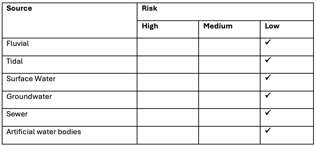
The Environment Agency Flood Maps for Planning show site is contained to Flood Zone 1. Flood Zone 1 is defined as land assessed as having an annual probability of river flooding of less than 1% and all land uses are acceptable. All other sources of flood risk, as summarised below, are considered to pose a low risk to the site.

Residential development is classified as more vulnerable in accordance with The National Planning Practice Guidance: Flood Zone and Flood Risk Tables. The proposed developmental is in an area at low risk of flooding, and therefore all residential development will be contained to areas at low risk flooding.

DRAINAGE

The site falls from south to north. A ditch course is noted to the north of Mallory Road and is considered to be the existing route for overland flows on the site. Surface water flows will be conveyed to an attenuation basin located in the northern part of the site, adjacent to Mallory Road. Discharge rates will be restricted to below existing greenfield runoff rates and a storage volume of approximately 2,000m3 will be provided to cater for 1 in 100 year plus climate change storm event. Suitable treatment of surface water flows will be provided for in accordance with relevant guidance.

Foul drainage will discharge into the existing Severn Trent Water sewer network to the east of the site. Given the site levels, foul water will need to be pumped via a new pumping station on site. In line with the requirements of the Water Industry Act, Thames Water will be required to ensure suitable capacity is made available.

HAVE YOUR SAY